Sorry your browser is not supported!

You are using an outdated browser that does not support modern web technologies, in order to use this site please update to a new browser.

Browsers supported include Chrome, FireFox, Safari, Opera, Internet Explorer 10+ or Microsoft Edge.

DarkBASIC Professional Discussion / Random 2D World Map Generator function request

Author
Message
GIDustin
17
Years of Service
User Offline
Joined: 30th May 2008
Location:
Posted: 31st Jul 2010 03:16 Edited at: 31st Jul 2010 03:17
The game I am working on will have a huge map. I intend for exploration to one of the major strong points in the game. If I intend to play my own game, I will need to not have prior knowledge of the land. Therefore I need to create a random map generator.

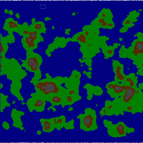
The type I am looking for is one similar to the maps you get in Civilization 3 or 4. The top and bottom 5-10 rows are all ice to prevent traveling to the edge. The left and right edges wrap around. The map will be 2500x2500, with a scale of 5 miles per tile. Cities will be placed roughly 10 tiles apart, and it should take players about 30 seconds to move from one tile to the other. Therefore, it would take ~21 hours real life time to circumnavigate the world. Huge right?

So here lies the problem: Creating a realistic world using a random generator. I want several (3-5) large continents, hundreds of small islands (100 tiles or so). Terrain types include most of the same ones from civilization: Grassland, Plains, Swamp, Jungle, Light/Dense forest, Desert, Ocean, Sea, Rivers, Mountains, Hills, Tundra and Ice.

I cannot think of a reliable method of making a realistic world. The Ice at the top was easy; just make the top 2-3 rows completely ice, and rnd(1) the next 2-3 rows to somewhat smooth it out. I am now at the part where I need to make continents. My first attempt was something similar to the following:


The problem I had there was that there were alot of smaller, really round islands and no real continents since everything was random. I am sure once I get the continents made, I can move on to adding mountains at random spots, but the continents is bothering me. Occasionally, about 1 in 10 maps made does come up with something feasible, but I really need something more reliable than that. See the attached image for my idea of feasible.

Any suggestions?


Attachments

Login to view attachments
Diggsey
19
Years of Service
User Offline
Joined: 24th Apr 2006
Location: On this web page.
Posted: 31st Jul 2010 15:07 Edited at: 31st Jul 2010 15:13
Calculate a height for each cell using this algorithm:

http://en.wikipedia.org/wiki/Diamond-square_algorithm

(It will automatically wrap around)

Then choose a sea level height. Anything below that height is sea.

You could make any cell above a certain height a hill, and if it is even higher, you could make it a mountain.

Here's an example image generated:


You can fade the top and bottom to ice gradually.

[b]
Green Gandalf
VIP Member
20
Years of Service
User Offline
Joined: 3rd Jan 2005
Playing: Malevolence:Sword of Ahkranox, Skyrim, Civ6.
Posted: 31st Jul 2010 16:15
Or use Perlin noise without some of the octaves.

I'll post a simple demo in about half an hour (lunch is ready now ).
Green Gandalf
VIP Member
20
Years of Service
User Offline
Joined: 3rd Jan 2005
Playing: Malevolence:Sword of Ahkranox, Skyrim, Civ6.
Posted: 31st Jul 2010 16:34
Lunch is unexpectedly delayed.

Here's the demo. It's "work in progress" so several features haven't been implemented yet. Just run the demo, click on a few "octave" buttons then press "make image". The image will be displayed and saved when you press the space key.

Perlin noise is far more flexible than the diamond square algorithm (I've posted another demo using that somewhere ).

Attachments

Login to view attachments
Devonps
15
Years of Service
User Offline
Joined: 5th Nov 2009
Location: Nottingham
Posted: 31st Jul 2010 16:57 Edited at: 31st Jul 2010 16:57
You could do no worse than check out the Dwarf Fortress feature list (see near the bottom) for inspiration and their wiki for world generation tips.

I realise it's a roguelike but it may help you decide how realistic you want to go.

Marriage is a circle of rings....
Engagement ring, Wedding ring, Suffering!
GIDustin
17
Years of Service
User Offline
Joined: 30th May 2008
Location:
Posted: 31st Jul 2010 20:14 Edited at: 5th Aug 2010 05:56
@Diggsey: Your image looks close to what I want, just throw in some random smaller islands which should be easy to do. I went to the link and I understand the square concept, but how to change that to a diamond is a bit confusing.

@Green Gandalf: Nice program. I like the results when combining octaves 2-4 or 2-5 and upping the sharpness a bit. If this is just a work in progress, then I can't wait for the finished product.

@Devonps: Your first link doesn't work for me, and the second looks like it contains data for use with the first because it doesn't have any formulas or anything. I will check into it though since they have alot of terrain types listed though.

So far I really like the responses. I am going to spend the whole day trying to implement them so keep em coming.

Attachments

Login to view attachments
GIDustin
17
Years of Service
User Offline
Joined: 30th May 2008
Location:
Posted: 2nd Aug 2010 00:31
Tried the Diamond Square algorithm and I am not seeing the results I want. I think I messed up somewhere, especially since the map doesn't wrap on the X axis.

I am going to keep trying with it though.

@Green Gandalf: Do you know when your Perlin noise algorithm program will be completely finished? I checked the source code and it looks complex already so I can't imagine...

Neuro Fuzzy
17
Years of Service
User Offline
Joined: 11th Jun 2007
Location:
Posted: 2nd Aug 2010 01:11
here's a really good read if you're interested in the highly awesome perlin noise algorithm: http://freespace.virgin.net/hugo.elias/models/m_perlin.htm


Is't life, I ask, is't even prudence, to bore thyself and bore thy students?
Green Gandalf
VIP Member
20
Years of Service
User Offline
Joined: 3rd Jan 2005
Playing: Malevolence:Sword of Ahkranox, Skyrim, Civ6.
Posted: 2nd Aug 2010 01:24
Here's a cloudy sky/random terrain making program I posted some time back. It uses the diamond-square algorithm. You'll need to change the line concatenation symbol from ... to whatever you use (or put everything affected on one line).

random heightmap and cloudy sky generator for DBP5.8

You can change various options in these lines:


For example, n=10 gives a 1024x1024 image, cloud=0 gives a heightmap and e=0 allows the edges to be random.
GIDustin
17
Years of Service
User Offline
Joined: 30th May 2008
Location:
Posted: 2nd Aug 2010 07:41
@Neuro Fuzzy
Thanks for the link, now I have reading material for lunch at work tomorrow

@Green Gandalf
Tried your snippet with n=11 (2048x2048) and it is REALLY close to what I want. Is one of those crytically named variables in control of how many smaller "clouds" appear?

I finished my test run with Diamond-square and it didn't turn out well. Most of these algorithms, when put to use making random terrain, allow for one larger landmass and that is about it. I am looking for several large landmasses so I may have to do several of these algorithms and smooth them together. Also, even the image Diggsey posted above has terrain that touches the north and south border, which I am trying to avoid.

I do however think that enough material has been posted for me to make a hybrid script to achieve my goals.

Green Gandalf
VIP Member
20
Years of Service
User Offline
Joined: 3rd Jan 2005
Playing: Malevolence:Sword of Ahkranox, Skyrim, Civ6.
Posted: 2nd Aug 2010 13:54
Quote: "Also, even the image Diggsey posted above has terrain that touches the north and south border, which I am trying to avoid."


That's easy to fix in my code - just keep e=1 in this line


It's not so easy to control the number of land masses.

What I do in this situation is create some crudely shaped islands first using random filled circles then use the other image values to randomize the heights a bit. As you say, a hybrid approach is probably necessary.

Let us know how you get on.
GIDustin
17
Years of Service
User Offline
Joined: 30th May 2008
Location:
Posted: 2nd Aug 2010 15:43 Edited at: 2nd Aug 2010 15:45
Quote: "It's not so easy to control the number of land masses. "


I think I have a plan. I am going to split my "canvas" into 25 sub-squares, then randomly create groups, and use your script on each group. I believe this is how SimCity 4 splits its world maps into sub-cities. Can your script be modified to use rectangles or is it just squares?

In this image, I would get 8 reasonably sized landmasses.


Attachments

Login to view attachments
Green Gandalf
VIP Member
20
Years of Service
User Offline
Joined: 3rd Jan 2005
Playing: Malevolence:Sword of Ahkranox, Skyrim, Civ6.
Posted: 2nd Aug 2010 16:52
Good idea. Wish I'd thought of that.

It's been a while since I looked into this but I think the basic diamond-square algorithm only works for squares.

One solution, a bit of a hack really, might be to add a bit of code to my program to set the unwanted part of the square equal to a constant in the same way that I have an option that fixes the edges (e = 1). You could probably use essentially the same code just using the unwanted rectangle as well as the edge. Haven't tested this though so it comes with the usual health warning.
Then you'd just use the part of the final image you needed.
Sven B
20
Years of Service
User Offline
Joined: 5th Jan 2005
Location: Belgium
Posted: 2nd Aug 2010 23:29 Edited at: 2nd Aug 2010 23:30
Hi there,

A while ago I gave a go at some paper about procedural terrain generation I came across. It has a separate function for the diamond square algorithm. It also contains a function for creating a Voronoi diagram.
It also uses code for applying an offset map, and a function for simulating basic thermal and hydraulic erosion. If you have my Image Kit plugin, then you can also use the functions for generating a texture (media and exe included).

Cheers!
Sven B

Attachments

Login to view attachments
GIDustin
17
Years of Service
User Offline
Joined: 30th May 2008
Location:
Posted: 3rd Aug 2010 06:53 Edited at: 3rd Aug 2010 06:54
I tried the method I mentioned above with the colorful square and it didnt work. The main reason is that the large purple square is 1536x1536, which is not a power of 2.

So I redid my color square, and modified the code to allow for not-so-squares and got this.


I need to make it look not-so-tiled, so that will be the next version.

Just keeping you all up to date.

Attachments

Login to view attachments
Green Gandalf
VIP Member
20
Years of Service
User Offline
Joined: 3rd Jan 2005
Playing: Malevolence:Sword of Ahkranox, Skyrim, Civ6.
Posted: 3rd Aug 2010 12:57
I did a bit of experimenting yesterday and got results similar to yours. I found that by adding a cutoff value I was able to get islands surrounded by black - but not all the time. This helped get rid of the straight edges between the squares but not completely.

I still favour proceeding in two steps. First produce a random set of blurred blobs representing islands, etc. Then modify this by blending with the cloud image in some way. But your approach is neater so I'm interested in how you get on.
Mugen Wizardry
User Banned
Posted: 3rd Aug 2010 13:11
If is maximised(GET DBPRO WINDOW()) or is fullscreen()=0
set active window GET DBPRO WINDOW()
Endif

CHECK OUT SOME MUSIC FROM MY NEW TECHNO CD! TECHNOKINESIS
http://www.youtube.com/watch?v=4a8KedfgVv0
ALSO, CHECK OUT MY NEW TECHNO CD! http://www.imageposeidon.com/
Madscientist
15
Years of Service
User Offline
Joined: 23rd Aug 2009
Location: Between a rock and a hard place
Posted: 3rd Aug 2010 18:12
WHAT?? Mugen Wizardry
Random much??


If it hasn't exploded yet, I haven't touched it.
Mugen Wizardry
User Banned
Posted: 3rd Aug 2010 19:17
hey, relax.

i did that at 5 am this morning.

and that was supposed to go in the modal window post lol.

not here

CHECK OUT SOME MUSIC FROM MY NEW TECHNO CD! TECHNOKINESIS
http://www.youtube.com/watch?v=4a8KedfgVv0
ALSO, CHECK OUT MY NEW TECHNO CD! http://www.imageposeidon.com/
GIDustin
17
Years of Service
User Offline
Joined: 30th May 2008
Location:
Posted: 4th Aug 2010 16:20
Quote: "I did a bit of experimenting yesterday and got results similar to yours. I found that by adding a cutoff value I was islands surrounded by black - but not all the time. This helped get rid of the straight edges between the squares"


What do you mean add a cutoff value? Like any square below 30/255 is considered 0?

Green Gandalf
VIP Member
20
Years of Service
User Offline
Joined: 3rd Jan 2005
Playing: Malevolence:Sword of Ahkranox, Skyrim, Civ6.
Posted: 4th Aug 2010 16:44
Yes - and then reduce the others by 30 (or 29?) so you get a smooth transition on the edges.
GIDustin
17
Years of Service
User Offline
Joined: 30th May 2008
Location:
Posted: 5th Aug 2010 05:56 Edited at: 5th Aug 2010 05:57
Well I tried the colored square method above and it still looked too "tiled", so I thought I would random the squares a bit. Came up with something that generates these babies:


I thought it would go great, but it didn't. I ran each colored section through Green Gandalf's algorithm and pasted them all together. This is the result:


Not what I was expecting.... You can still clearly see the borders. Back to the drawing board.

Attachments

Login to view attachments
Diggsey
19
Years of Service
User Offline
Joined: 24th Apr 2006
Location: On this web page.
Posted: 5th Aug 2010 12:50 Edited at: 5th Aug 2010 12:51
You could generate heights using perlin noise, and then multiply each high by its distance from the north or south pole (up to a maximum of 1)

That way the heights would tend to 0 at the top and bottom, while leaving the middle as normal. If you then make every square higher than 60 (assuming the range is 0-100) land and the rest water, you should get some islands and things.

If you need to make islands more pronounced, then when making the heights go to zero near the poles, you could pick a number of random points. You find the distance to the nearest point from each tile and the larger it is, the closer you make it's height to zero. This should produce more distinct islands.

[b]
Green Gandalf
VIP Member
20
Years of Service
User Offline
Joined: 3rd Jan 2005
Playing: Malevolence:Sword of Ahkranox, Skyrim, Civ6.
Posted: 5th Aug 2010 13:35
Quote: "Not what I was expecting.... You can still clearly see the borders. Back to the drawing board."


Yes, that's the problem I was talking about - only worse. When you calculate each block do you set all the values on the edges and outside the block to zero (or some other value, I forget which I used in my code)? The variable e controls that - but you'd need to add extra code in your case.
GIDustin
17
Years of Service
User Offline
Joined: 30th May 2008
Location:
Posted: 5th Aug 2010 15:49
Yeah, here is the quick and dirty example of what I did above


Obviously that code wont compile but it gets the general idea out there with what I was going for. It only appears to not work on tiles that arent either square or rectangle. Maybe my tetris piece idea won't work...

Green Gandalf
VIP Member
20
Years of Service
User Offline
Joined: 3rd Jan 2005
Playing: Malevolence:Sword of Ahkranox, Skyrim, Civ6.
Posted: 5th Aug 2010 19:21
I think it should work - except that sometimes the straight edges will still show. I'll try to find time to reproduce the problem.

You may still be better off producing a random list of island "centres" and using that information to modify the raw heightmap. Similar to Diggsey's suggestion I guess.
Diggsey
19
Years of Service
User Offline
Joined: 24th Apr 2006
Location: On this web page.
Posted: 5th Aug 2010 21:14 Edited at: 5th Aug 2010 21:14
I got this using the method I described above:


Is that closer to what you want?

[b]

Attachments

Login to view attachments
Green Gandalf
VIP Member
20
Years of Service
User Offline
Joined: 3rd Jan 2005
Playing: Malevolence:Sword of Ahkranox, Skyrim, Civ6.
Posted: 5th Aug 2010 22:27 Edited at: 5th Aug 2010 22:30
And I got this using a completely different method:


I prefer Diggsey's.


[Edit: changed image colours.]

Attachments

Login to view attachments
GIDustin
17
Years of Service
User Offline
Joined: 30th May 2008
Location:
Posted: 6th Aug 2010 01:41
Quote: "You could generate heights using perlin noise, and then multiply each high by its distance from the north or south pole (up to a maximum of 1)"


Then all the mountain peaks would be in the center of the world. I want to use the same height-map for sea level and hill/mountain level as well.

Quote: "If you need to make islands more pronounced, then when making the heights go to zero near the poles, you could pick a number of random points. You find the distance to the nearest point from each tile and the larger it is, the closer you make it's height to zero. This should produce more distinct islands"


Interesting thought. I would have to somehow coordinate the "center of island" positions with positions that the perlin noise already considered "above sealevel". For smaller islands I think it would work but not for continents as I would rather them not be too rounded.

Quote: "I got this using the method I described above:"

The method being your random island center technique? That image has a bit too much water for my tastes but a simple change to the sea level value would fix that. This wont be a very naval-based game so by either growing the current landmasses or creating new ones (that hopefully don't mend in with its neighbors) would be ideal.

Quote: "And I got this using a completely different method: "

What method was that? The landmasses are really round shaped, and I the shores look like someone cut them out with a dull knife.

Quote: "Yes, that's the problem I was talking about - only worse. When you calculate each block do you set all the values on the edges and outside the block to zero (or some other value, I forget which I used in my code)? The variable e controls that - but you'd need to add extra code in your case. "

Yup, that is exactly what I did. You cant tell from that resized screenshot but about 4 pixels from the border of each colored block it does go from whatever value it was back down to 0 at the border, but it does it at such an extremely slope that it looks tiled still. Again, it only does this weird effect if the blocks are not rectangles so I might just stick with rectangles...

DVader
21
Years of Service
User Offline
Joined: 28th Jan 2004
Location:
Posted: 6th Aug 2010 02:04 Edited at: 6th Aug 2010 02:10
I am fascinated with this thread. I don't understand a word, but interested all the same . Diggsey that map is very like a world map minus most of Russia, China, the middle east and India. You using some sort ww3 test algorithm? looks cool all the same, imitating nature like this always impresses me.
@ green gandalf, your image looks very leafish in shape, except badly eaten leaves Looks cool as well.
Edit - Oh I noticed good old Blighty is gone too, that's bad news for me... In fact unless you live in Africa that map looks a little bleak for all concerned lol.

http://s6.bitefight.org/c.php?uid=103081
Green Gandalf
VIP Member
20
Years of Service
User Offline
Joined: 3rd Jan 2005
Playing: Malevolence:Sword of Ahkranox, Skyrim, Civ6.
Posted: 6th Aug 2010 02:29
Quote: "What method was that?"


A method that needs improvement.

Quote: "Again, it only does this weird effect if the blocks are not rectangles so I might just stick with rectangles..."


I got it with rectangles too, but not all the time. Perhaps it depends on which part of the enclosing square you use?

Quote: "except badly eaten leaves"


Like the cabbages in my garden.
leo877
17
Years of Service
User Offline
Joined: 6th Mar 2008
Location: san antonio, tx
Posted: 6th Aug 2010 02:34
just want to say , diggsy your map looks like what global warming has hit.

green your map looks like a paint ball effect
and abstract art.

gidustin s tertis art.


Diggsey
19
Years of Service
User Offline
Joined: 24th Apr 2006
Location: On this web page.
Posted: 6th Aug 2010 03:33 Edited at: 6th Aug 2010 03:34
Quote: "Then all the mountain peaks would be in the center of the world."


I only meant the very top and bottom, there would be a large range in the middle which would be unaffected.

Quote: "I would have to somehow coordinate the "center of island" positions with positions that the perlin noise already considered "above sealevel". For smaller islands I think it would work but not for continents as I would rather them not be too rounded."


But you don't because that's what makes it random, if you do an island in a low area, it remains low, it's only when it's far from an island and it's high that it will go lower.

Quote: "The method being your random island center technique? That image has a bit too much water for my tastes but a simple change to the sea level value would fix that. This wont be a very naval-based game so by either growing the current landmasses or creating new ones (that hopefully don't mend in with its neighbors) would be ideal."


You can change the threshold value to get more or less land, but if you want lots of islands you have to have lots of sea to go around the islands (And it's missing the north and south poles on that picture)

To create that image I did the following steps in GIMP:
- render clouds to a white layer
- make a new white layer which goes to black at the top and bottom
- make a new grey layer and place random white blobs on it with the largest and softest paintbrush, making sure it wraps around correctly
- multiply all the layers together
- colours->threshold and adjust the slider until you get a good result
- then I simply replaced black with blue and white with green

[b]
GIDustin
17
Years of Service
User Offline
Joined: 30th May 2008
Location:
Posted: 6th Aug 2010 06:59 Edited at: 6th Aug 2010 06:59
Quote: "To create that image I did the following steps in GIMP:"


I got similar results with Photoshop, very nice. Unfortunately DBPro doesnt have a photoshop plugin. Also, the ending part where you adjust the threshold would need human interaction to get perfect. The process of creating those layers though gave me some ideas for future algorithms if I need them.

I think I have enough methods for creating continents and islands. Now is the even harder part: determining where the mountain ranges are. I tried using the same method as I do for sea level if Map(x.y).Elevation > MountainLevel but the problem is that each "region" would have a different MountainLevel. Think of some of the lowest mountain ranges in the world. The elevation of those mountains is much larger than the surrounding terrain, however somewhere in the world there is an area with the same elevation that is considered flat in comparison to the mountain ranges nearby. Kinda see what I mean?

So, trying now to think of how to get past that hurdle. For example, in this test map you can see mountain ranges (value > 235 out of 255) on 3 landmasses where the ranges are huge. Then, on others, there are none at all. This just doesn't look right. The "MountainLevel" needs to be determined on a local basis, whether it is by landmass or by a set radius...


Attachments

Login to view attachments
Green Gandalf
VIP Member
20
Years of Service
User Offline
Joined: 3rd Jan 2005
Playing: Malevolence:Sword of Ahkranox, Skyrim, Civ6.
Posted: 6th Aug 2010 11:55
Quote: "Kinda see what I mean?"


Not really.

Quote: "This just doesn't look right."


Looks fine to me. Perhaps you just need more intermediate colours/levels?

Quote: "The "MountainLevel" needs to be determined on a local basis, whether it is by landmass or by a set radius..."


Not sure I understand the problem.
GIDustin
17
Years of Service
User Offline
Joined: 30th May 2008
Location:
Posted: 7th Aug 2010 04:50
OK, did some googling to find an answer and didn't get one in a reasonable amount of time.

Say there is some land at just above sea level. On that land is a mountain range that peaks at 3,000 ft. Clearly this 3,000 ft area is considered a mountain range when compared to the almost sea level land around it.

Then, halfway across the world we get a larger landmass. There is a nice, flat area of land in the center with an elevation of 4,000 ft, and mountains nearby with an elevation of 10,000 ft.

Using our math, if a 3,000 ft high area (the first island) is considered a mountain range, then the entire flat area of the other larger landmass is also a mountain range, even though it is relatively flat and has an area even taller nearby. However, if we up the "mountain range elevation" to 5,000 ft or so to deal with the larger landmass, then the mountain on the smaller landmass is no longer considered a mountain.

If you want real-world examples, I will be forced to call upon my geographically inclined friend. I bet he can list one mountain range that has an elevation LOWER than a flatter area of land somewhere else in the world.

IMHO mountains should be defined as an area with an elevation that is a certain percent higher than the surrounding area. Without knowing the percent, or how big the "surrounding area" is in advance, it would be hard to code...
Green Gandalf
VIP Member
20
Years of Service
User Offline
Joined: 3rd Jan 2005
Playing: Malevolence:Sword of Ahkranox, Skyrim, Civ6.
Posted: 7th Aug 2010 12:43
I really don't understand what you're trying to say.

Some islands will have low hills or mountains, others, typically larger ones but not necessarily, will have higher ones. What's the problem?
GIDustin
17
Years of Service
User Offline
Joined: 30th May 2008
Location:
Posted: 7th Aug 2010 21:03
If each square on the map has an elevation in the range of 0-255, the problem is that I cant just say "Any square over 235 in height is a mountain" because the height at which an area is considered a mountain will be different for each region based on that region's specific minimum and maximum heights.

I finished my river creation technique. It randomly places "river seeds" onto tiles on the map, with mountain and hill squares having a higher chance of receiving one. Then each one "flows" with the elevation until it either hits another river, pools into a lake, or reaches the ocean. They look really good, but will look even better once I get my mountain/hill elevation problem sorted out.

Next on the list is adding the other terrain types; forest, jungle, desert, swamp, etc. For this I will need to research what latitude/longitude each is most commonly found, the climates and wind patterns that create each. I am going to be on Google all day.
Green Gandalf
VIP Member
20
Years of Service
User Offline
Joined: 3rd Jan 2005
Playing: Malevolence:Sword of Ahkranox, Skyrim, Civ6.
Posted: 7th Aug 2010 21:28
Quote: "They look really good, but will look even better once I get my mountain/hill elevation problem sorted out."


I still don't see what the problem is.

Perhaps you've got "elevation" and "slope" confused? It sounds like you should be calculating the slope so that you ensure rivers flow downhill. I don't see what elevation has to do with it.

I would just calculate the slope in each of the 8 possible directions from a given pixel and assume the river flows down the steepest one into the corresponding adjacent pixel and so on till you hit the sea or a lake - plus some extra code to give the river some width.
GIDustin
17
Years of Service
User Offline
Joined: 30th May 2008
Location:
Posted: 8th Aug 2010 01:42
After talking to my friend, I think mountains need redone entirely. In the real world, mountains are not center-pieces to larger landmasses. Mountains occur where tectonic plates collide. So, my next generation map maker will create the landmasses, and then create tectonic plates, and multiply the height of the tiles of the landmasses based on their distance from a tectonic plate border. This will create the long stringy mountain ranges found on Earth, instead of the cone shaped ones I am getting now.

Login to post a reply

Server time is: 2025-06-04 19:10:44
Your offset time is: 2025-06-04 19:10:44