Extended Terrain XYZ (
original post,
outdated website) is a Dark BASIC Pro project of mine from 5 years ago. It is a layer based, realtime mapeditor. It's perfectly compatible with DBPro and DGDK, the maps are importable through one command. You can also export heightmaps for use in other engines.
You can edit the terrainheights, texture, blendcolor and (- the name giving feature -) also the xz coordinate of each point. This can be used for some cool effects such as small caves and overhangs.
The Dark Basic import code is also compatible with Sparky's Collsion Plugin and Dark Physics.
List of features
This is an incomplete list of the features this editor has to offer:
• Up to 8 layers, each with its own texture and texture scale
• Up to 150'000 (~387^2) grid points supported
• Windowed, resizable application
• Very fast undo functionality
• Very fast saving
• Very fast importing in both DBP and DGDK
• Brush editor
• Subdivided model for efficient culling
• Multi Language support - English, German and French translations included
• Supports BMP, JPG, TGA, DDS, DIB or PNG format textures and heightmaps (.bmp export only) and exports the terrain in its own .etm file format for which loading code is provided.
Download
Download Extended Terrain XYZ - Open Source
(hotlink hosted on
Dropbox,
stats,
d - if you like this project, please consider joining Dropbox over
my referral link which will give both of us an additional free 500 MB)
• Download all required extensions (for compiling the source code)
here
• Some additional textures and demo maps:
here (26 MB) (
stats,
d)
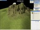
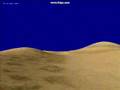
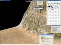
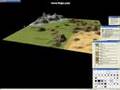
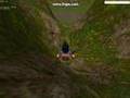
Screenshots


Videos:
 Source code
As the title says, this is not only free but also open source software. Since DBPro and BlueGUI 2 are free now, anybody can compile and modify this. Also uses some other free extensions, see included ReadMe.txt for more details (let me know if I missed a plugin). The required plugins can be downloaded above.
Final Words
I hope you'll like it and find the code useful. If you do like this, check my
Game Maker Terrain Editor over at the GMC and my other projects there (see my signature there), as well as my website
http://www.hurricane-eye.webs.com/.
Regards,
- Paul